![](/images/other/stat-length.png)
![Randonnée A pied Groß Kreutz (Havel) - Mühlenrundweg - Photo](https://media.geolcdn.com/t/1900/400/1ed45252-7a8a-4252-9e38-776b09adb48f.jpeg&format=pjpeg&maxdim=2)
Mühlenrundweg
SityTrail - itinéraires balisés pédestres
Tous les sentiers balisés d’Europe GUIDE+
![Longueur](/images/other/stat-length.png)
Longueur
3,1 km
![Altitude max](https://static1.geolcdn.com/siteimages/upload/files/1508320355ic_sort_altitude_max_24dp.png)
Altitude max
71 m
![Dénivelé positif](https://static1.geolcdn.com/siteimages/upload/files/1508320355ic_sort_den_pos_24dp.png)
Dénivelé positif
58 m
![Km-Effort](/images/other/stat-length.png)
Km-Effort
3,9 km
![Altitude min](https://static1.geolcdn.com/siteimages/upload/files/1508320355ic_sort_altitude_min_24dp.png)
Altitude min
30 m
![Dénivelé négatif](https://static1.geolcdn.com/siteimages/upload/files/1508320355ic_sort_den_neg_24dp.png)
Dénivelé négatif
58 m
![Boucle](https://static1.geolcdn.com/siteimages/upload/files/16400158638029165_repeat_loop_refresh_sync_direction_icon.png)
Boucle
Oui
Balise
Date de création :
2022-02-11 19:02:35.826
Dernière modification :
2022-02-11 19:02:35.826
![A pied](https://static1.geolcdn.com/sitytour/trail-icons/100.png)
53m
Difficulté : Facile
![Scannez ce code QR pour ouvrir la randonnée dans l'application SityTrail](https://capi.geolives.com/qq0zvz2zws4bq2lad0pu/sitytour/trails/3100172/qr.png?size=200)
Application GPS de randonnée GRATUITE
À propos
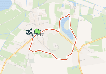
Randonnée A pied de 3,1 km à découvrir à Brandebourg, Potsdam-Mittelmark, Groß Kreutz (Havel). Cette randonnée est proposée par SityTrail - itinéraires balisés pédestres.
Description
Symbole: yellow dot on white background
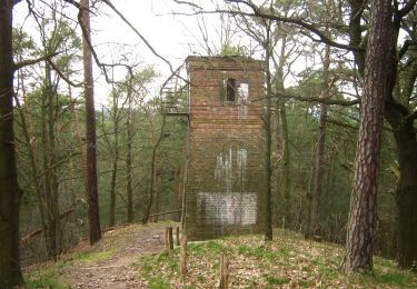
Localisation
Pays :
Allemagne
Région :
Brandebourg
Département/Province :
Potsdam-Mittelmark
Commune :
Groß Kreutz (Havel)
Localité :
Unknown
Départ:(Dec)
Départ:(UTM)
348444 ; 5812863 (33U) N.
Commentaires
Randonnées à proximité
![Randonnée A pied Kloster Lehnin - Baumkreis-Wanderweg - Photo](https://media.geolcdn.com/t/375/260/c84e3bee-1225-42aa-8049-f1e2c6f0044e.jpeg&format=jpg&maxdim=2)
![A pied A pied](https://static1.geolcdn.com/sitytour/trail-icons/100.png)
Baumkreis-Wanderweg
A pied
Facile
Kloster Lehnin,
Brandebourg,
Potsdam-Mittelmark,
Allemagne
![](/images/other/stat-length.png)
7,9 km | 8,6 km-effort
1h 56min
![](https://static1.geolcdn.com/siteimages/upload/files/16400158638029165_repeat_loop_refresh_sync_direction_icon.png)
Non
![Randonnée A pied Kloster Lehnin - Rundwanderweg Klostersee - Photo](https://media.geolcdn.com/t/375/260/3fd02ec0-c99f-45c4-b89e-83c0d3f2284c.jpeg&format=jpg&maxdim=2)
![A pied A pied](https://static1.geolcdn.com/sitytour/trail-icons/100.png)
Rundwanderweg Klostersee
A pied
Facile
Kloster Lehnin,
Brandebourg,
Potsdam-Mittelmark,
Allemagne
![](/images/other/stat-length.png)
7,4 km | 8,1 km-effort
1h 50min
![](https://static1.geolcdn.com/siteimages/upload/files/16400158638029165_repeat_loop_refresh_sync_direction_icon.png)
Oui
![Randonnée A pied Kloster Lehnin - Kloster-Havel-Wanderweg - Photo](https://media.geolcdn.com/t/375/260/c84e3bee-1225-42aa-8049-f1e2c6f0044e.jpeg&format=jpg&maxdim=2)
![A pied A pied](https://static1.geolcdn.com/sitytour/trail-icons/100.png)
Kloster-Havel-Wanderweg
A pied
Facile
Kloster Lehnin,
Brandebourg,
Potsdam-Mittelmark,
Allemagne
![](/images/other/stat-length.png)
7,9 km | 8,6 km-effort
1h 56min
![](https://static1.geolcdn.com/siteimages/upload/files/16400158638029165_repeat_loop_refresh_sync_direction_icon.png)
Non
![Randonnée A pied - Marquardt - Nedlitz - Photo](https://media.geolcdn.com/t/375/260/440405cd-d91a-43d6-b01a-85fdff20ad6c.jpeg&format=jpg&maxdim=2)
![A pied A pied](https://static1.geolcdn.com/sitytour/trail-icons/100.png)
Marquardt - Nedlitz
A pied
Facile
,
Brandebourg,
Potsdam,
Allemagne
![](/images/other/stat-length.png)
7,6 km | 8,4 km-effort
1h 54min
![](https://static1.geolcdn.com/siteimages/upload/files/16400158638029165_repeat_loop_refresh_sync_direction_icon.png)
Non
![Randonnée A pied - Kleine Wildpark-Route - Photo](https://media.geolcdn.com/t/375/260/9bb0f4ba-aecf-4422-9065-5b1e7cfc3d08.jpeg&format=jpg&maxdim=2)
![A pied A pied](https://static1.geolcdn.com/sitytour/trail-icons/100.png)
Kleine Wildpark-Route
A pied
Facile
,
Brandebourg,
Potsdam,
Allemagne
![](/images/other/stat-length.png)
3,3 km | 3,7 km-effort
50min
![](https://static1.geolcdn.com/siteimages/upload/files/16400158638029165_repeat_loop_refresh_sync_direction_icon.png)
Non
![Randonnée A pied - Waldlehrpfad Pirschheide - Photo](https://media.geolcdn.com/t/375/260/9bb0f4ba-aecf-4422-9065-5b1e7cfc3d08.jpeg&format=jpg&maxdim=2)
![A pied A pied](https://static1.geolcdn.com/sitytour/trail-icons/100.png)
Waldlehrpfad Pirschheide
A pied
Facile
,
Brandebourg,
Potsdam,
Allemagne
![](/images/other/stat-length.png)
4,1 km | 4,6 km-effort
1h 2min
![](https://static1.geolcdn.com/siteimages/upload/files/16400158638029165_repeat_loop_refresh_sync_direction_icon.png)
Non
![Randonnée A pied - Zum Kleinen Ravensberg - Photo](https://media.geolcdn.com/t/375/260/480d5ce1-c994-4ea2-a81f-b242b6ffe9b6.jpeg&format=jpg&maxdim=2)
![A pied A pied](https://static1.geolcdn.com/sitytour/trail-icons/100.png)
Zum Kleinen Ravensberg
A pied
Facile
,
Brandebourg,
Potsdam,
Allemagne
![](/images/other/stat-length.png)
6,2 km | 7,3 km-effort
1h 39min
![](https://static1.geolcdn.com/siteimages/upload/files/16400158638029165_repeat_loop_refresh_sync_direction_icon.png)
Non
![Randonnée A pied Michendorf - Balken grün Caputh - Lienewitzseen - Photo](https://media.geolcdn.com/t/375/260/6757b860-b8b5-4914-9ac2-b5c8f61652e1.jpeg&format=jpg&maxdim=2)
![A pied A pied](https://static1.geolcdn.com/sitytour/trail-icons/100.png)
Balken grün Caputh - Lienewitzseen
A pied
Facile
Michendorf,
Brandebourg,
Potsdam-Mittelmark,
Allemagne
![](/images/other/stat-length.png)
3,7 km | 4,2 km-effort
57min
![](https://static1.geolcdn.com/siteimages/upload/files/16400158638029165_repeat_loop_refresh_sync_direction_icon.png)
Non
![Randonnée A pied - Bornim - Bf. Park Sanssouci über Grube - Photo](https://media.geolcdn.com/t/375/260/e6ea9d6b-1381-4320-888b-59fcd21f2365.jpeg&format=jpg&maxdim=2)
![A pied A pied](https://static1.geolcdn.com/sitytour/trail-icons/100.png)
Bornim - Bf. Park Sanssouci über Grube
A pied
Facile
,
Brandebourg,
Potsdam,
Allemagne
![](/images/other/stat-length.png)
6,2 km | 6,7 km-effort
1h 31min
![](https://static1.geolcdn.com/siteimages/upload/files/16400158638029165_repeat_loop_refresh_sync_direction_icon.png)
Non